Investing in Citian
TL;DR Crashes devastate. In just the U.S. each year, they kill 43,000 vehicle occupants and 7,500 pedestrians. Many more are injured. Sensors on all vehicles and roadways will bring better data than police reports, which are also not yet fully analyzed for insights. Citian (citiansolutions.com) brings Software tools for Civil Engineers to effectively sift through the data and plan roadway improvement projects that will have the highest impact on safety for dollars spent.
Citian = Serving Cities and their Pedestrians
Billions of data points give puzzle fragments for deducing which roadway and intersection designs are optimal at reducing risk to vehicle passengers and pedestrians. Trillions more are coming, as sensors and cameras become ubiquitous onboard cars and alongside roads. Roadway planners will need cutting-edge AI-capable Software tools. The assurance Civil Engineers bring to prescribing the most safety-helping interventions at scale should steadily grow through data-processing, analytics, and advanced simulations. Citian has emerged to serve this market. As the Washington, D.C.-based startup raises its first round of outside capital, I am pleased to back the Founder, Steven Houh, his team, and join alongside Nirman Ventures and other company advisors.
A traffic accident or a near miss can burn in our memory. The human and economic impact to a family and to society is staggering. Compounding the tragedy is that most incidents are avoidable, not from a random falling tree or malfunctioning vehicle. In the U.S. each year there are nearly ~43,000 annual vehicle fatalities (in 2021 and 2022, per U.S. NHTSA) and over 7,500 pedestrian fatalities (New York Times, July 2023). When roadway projects are planned and prioritized, how can the public be confident that these include a balance not only of expansions and repairs, but also rework projects needed to reduce risk at hotspots?
When moving to the Bay Area in 2018, our initial home was near to (at least what seemed to us) an awfully risky highway hotspot. Locals to the Bay Area familiar with driving between Mill Valley and the Golden Gate Bridge along Highway 101 know the steep, curvy, and often foggy climb from either direction that peaks at the Spencer Ave exit above Sausalito. The mix of conditions leads to frequent incidents, like the one we observed below one weekend morning from the nearby trails.

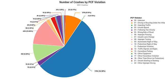
But how frequent, exactly? This could be classic observer bias. Data should help check, and public GIS tools allow anyone to query data. Within minutes, a data visualization of all the accidents along Highway 101 in Marin County during the past decade is accessible. During the 11 years, data indicate a crash on 4 out of every 5 days. Each year there were on average 4 lives lost and 400 injured.

Ahead of seeing the result, I assumed a large red dot indicating high accident frequency would be near that Spencer Avenue entrance to 101.See the actual dot — modest in size — in the center of the image below, in between the city label of Sausalito and the green dotted trails. This doesn’t appear so acute, especially relative to the higher concentration of red dots to the south along the stretch of 101 between Sausalito and the Golden Gate Bridge.

Incident data for this example was easy to access within minutes. Fortunately, most jurisdictions in the U.S. and beyond, good data sets are accessible. Most incidents have police documentation and are further elaborated upon and scrutinized for legal and insurance purposes. Unfortunately, the format often varies, existing toolkits have limitations, and data granularity have limits.
Bottom line: GIS data today says what happened yet inconsistently what roadway improvements might best help avoid a next time.
What an opportunity for modern AI tools! That’s also considering how richer data sets are soon coming from more vehicles with onboard cameras that record continuously in multiple directions. Perhaps by 2030, some areas regulate automatic police downloads from incident-observing and involved vehicles. This is much richer data than hand-written police reports of past decades.
No matter how much new data arrives detailing what happened, the harder questions come next:
- “What projects could and should reduce risk?”
- “How much budget should be spent at this site vs. the dozens of other problematic spots?”
And a bit like how society accepted stricter airline passenger TSA security measures in the post 9/11 era — costing more in taxes and time — for roadway safety:
- “What level of trade-offs will the public find justifiable for interventions like slower or weather-varying speed limits and automated fines for safer outcomes”
These analyses should be rigorous and thorough. Well-established guidelines and frameworks exist, though time-intensive work from civil engineers with expertise is costly and limited. Time-saving Software tools should bring value to this.
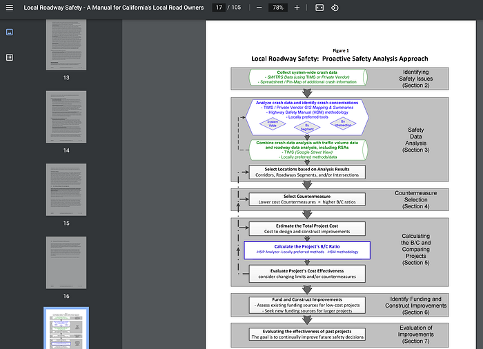
Citian sets out to digitize, analyze, propose, and harness a widespread community of expert civil engineers towards generating estimations for the safety and cost impacts of mitigations.
Industries like Healthcare and Financial Services gain broader media attention for their advancements deploying modern AI solutions. More of these run in real-time, able to ingest, process, and visualize changing situations. For example, hedge funds build rules engines to place real-time trades, or asset managers construct a rules-based exchange-traded fund (ETF) to keep liquidity and portfolio balance. Engineers at all levels Department of Transportation also deserve computing superpowers. A decade before ChatGPT roared onto the scene this year, IBM’s Watson captured imaginations about the future of predictive data science.
Across the recent articles on AI, many will cite at least one smart and balanced observer who says something along the lines of “good AI tools do not become the omnipotent overlord or boss, but instead the copilot”. At best, the tools smartly and objectively frame options that fit alongside a skilled planner’s own intuition and analyses. They crunch through and make useable more data that any person or team could handle. They help planners compare the likely cost and life-safety implications of potential rework to a roadway or intersection. More time planning and executing, less time wrangling the data. More lives saved. That’s what Citian’s tools intend to accomplish.

Standing out in a new wave of AI-powered Software will require a team with domain expertise that’s also proactive to envision that a best solution must hardness and leverage the domain expertise that exists throughout departments of transportation and specialized civil engineering firms. Citian’s founder, Steven Houh, spent the first half of his career immersed in this field as a Civil Engineer serving the Washington, D.C. metro area. After completing degrees at the University of Maryland, he joined Precision Systems Inc. in Washington, D.C. two decades earlier. Over time, he assumed leadership and grew the firm. Precision is known as a leading provider in the D.C. metro area especially for services related to road and intersection redesign and improvement. What started as an internal project around to build a better toolkit to digitize and analyze incident reports became interesting to other Engineering firms and Departments of Transportation beyond the nation’s capital. While Precision Systems helped form Citian, it’s now an independent company with Steven and the leadership team full-time. They’re now at the cusp of a growth opportunity, with dozens of states, counties, and cities ready to get underway after experiencing a demonstration and trial.
In one of the ten most populous U.S. states, the DOT is ready to move forward with Citian after a number of its cities have became active users. The statewide DOT employs five staff who encode police reports full time. A tech-minded manager there might have many options to try for saving time through AI-powered OCR tools rather than hiring a 6th employee. But a generic tool may take extra effort to tailor and implement. That’s because the goal isn’t just a factual replica of “what happened” but also incident analysis for “why it happened and what might have reduced to the risk or prevented it?”
Unique to Citian is this full project lifecycle vision of identifying hotspots, structuring mitigation measures, anticipating their costs, and suggesting how scarce tax dollars can best be deployed to save injuries and lives. CRASH (Crash reduction through Analysis of Safety Hazards) is its branded Software solution. In parallel, the company develops ADAPT (Accessibility Design, Assessment, and Planning Tool), a toolkit to spotlight and configure intersections for better compliance and improved safety for pedestrians with disabilities or challenges with mobility. Long-standing ADA regulations have not been evenly implemented across cities. Spotty controls and enforcement has gotten attention and in recent years pressure grows from advocacy groups and federal government for major cities like Chicago (Smart Cities Dive, 2023) and New York City (ABC News, 2020) to improve the status-quo and comply.
In the first years, Steven and the team have been engaging with DOTs across the U.S., and the response has been encouraging. Over 100 states, counties, and cities are now involved to kick the tires on demos and access a trial environment. Several dozen DOTs have signed on, and a next cohort plans its first steps to deploy. This motivates the team and investors who are especially reluctant that selling into government is a harder and longer process than into private enterprise. While Steven and the team have self-funded to this point, securing outside capital to ramp up hiring became urgent as there are dozens of DOTs committed and scheduled to start their implementations in the final months of 2023 and in 2024.
The potential for expansion is sizeable. In 2020, U.S. annual highway spending grew beyond $250B (U.S. Bureau of Transportation Statistics) and the latest bipartisan infrastructure package should lead to $470B in fresh spending for the years ahead (McKinsey, 2022). Districts will use Citian for its benefits but additionally can showcase its results and impact in grant writing to stand out while pursuing additional federal funds. Citian’s core team has worked with public departments for years and are familiar with the requisitions process critical for serving this market.
Based in Washington D.C., Citian’s team keeps in proximity to federal and state politics around transportation. The recent infrastructure spending package also included earmarks for spending on Construction technology, which remains underpenetrated in the industry with ample headroom to continue outpacing overall project spend (McKinsey, 2023).
A range of legacy solutions have brought incident tracking features and construction planning, yet not linked how to configure what intervention with what problematic roadway area. Two large incumbents deserve mention. ESRI is a 50-year old GIS Mapping industry giant with perhaps ~$1.5B annual sales ($1.3B, cited by a podcast two years ago) nearly 7,000 employees (and countless more implementation/support consultants). ESRI serves most jurisdictions. Bentley Systems is a 40-year old civil engineering project planning and management platform with ~$1.2B annual sales (TTM) over 5,000 employees. ESRI’s core strength is aggregating GIS data sets. ESRI helps governments log and query Where the problematic hotspots are. Later once intended projects are announced and bid, Bentley helps the E&C firms plan and project manage roadway improvements. This comes into play once we know project intent. But what’s the intent, and society’s preferred mix of projects? And who’s running A-B tests to validate if completed projects empirically realize their safety-improving aims? The missing linkage Citian helps address. Through digitally reconstructing and analyzing incidents, its algorithms work to determine Why a given spot is a hotspot, and What type of project or intervention is empirically-known to mitigate the risk to the greatest extent.
For the U.S. alone, estimations by the company and Nirman Ventures suggest that governments today may be spend around $3 per citizen in on Software for planning roadway improvements and ADA compliant crosswalks, making this a $1B serviceable market opportunity. This appears reasonable given the current level of sales for these two large reference companies. Bentley’s U.S. sales in 2022 were $459m and while privately-held ESRI does not segment sales by geography, its total sales volume is similar as Bentley’s. These are two from dozens of Software providers in this market. Long-standing usage of these Software implies DOTs have long-standing budget allocations to invest in this category, and staff in place to use them. A $1b — $2.5b USD relevant Software market implies only 0.5–1.0% of ($250b) roadway project expense is on planning Software. Across the Built environment as an industry, firms typically spends under 2% of revenue on Software & IT, lower than the 3.64% average Deloitte cites for all industries and still far lower more mature technology-using industries such as a Financial Services that spend 8%.
In the years ahead, everyone with an onboard vehicle camera or noticing cameras along highways can recognize that data inputs to statistical models are about to multiply. As downloading after an incident becomes the norm, theoretically regulators could imagine new ways of mandating or even automating anonymized data submissions not only for accidents but also for near misses, samples of data at certain intersections, or more.
While seeking to strike the right balance of innovation and safety, regulators and autonomous vehicles in San Francisco are having very active discussions, including the latest reversal on October 24 of Cruise’s permission to operate. And not only vehicles have sensors. Cities and highways have long deployed expensive CCTV for traffic monitoring and can now with the same budget afford many multiples more cameras and sensors as prices plunge for hardware and data connectivity. The data volume could become overwhelming. Are DOTs and Civil Engineering firms that serve them ready?
A vibrant market for aggregating, anonymizing, and sifting through roadway data will emerge. Startups may take an early lead for frontier innovations. Other industry examples repeatedly show how the large, incumbent software corporates can be slower to innovate while weighed down by management bureaucracies and existing product lines. They can also struggle to attract the high caliber of talent that fast-moving startups hire. A team like Citian will attract world-class AI/ML talent. They’re already off and running today with a usable toolkit helping process existing incidents reports and ensure usability by planners. Everyone who cares about public safety stands to benefit.
ESRI, Bentley, and many other developers of established solutions trusted by the industry won’t be asleep at the wheel as new data processing and planning needs arise. There will be multiple partnership opportunities to tie-in and provider users with value from using both tools. Citian will work to establish a respected and cooperative market position.
Working alongside co-investors including Nirman Ventures, I look forward to supporting Steven and his team through this next phase of growth, and along the long-term Vision Zero ambition shared by more and more companies, societies, and governments.
